
London Purchase Farm Arboretum - Map Design & Drone Imagery
Custom Map Design & Drone Imagery Services in Bucks County, PA

Drone aerial overview of London Purchase Farm Arboretum
Client: London Purchase Farm
Partner: May Horticultural Services
Location: Bucks County, Pennsylvania
Project Overview
London Purchase Farm is a historic estate in Bucks County with deep roots in American history—once the headquarters for George Washington’s Army and now home to a breathtaking private arboretum of rare specimen trees. When the owners wanted to enhance the experience for guests and preserve the beauty of the landscape, they turned to McNaught Design for our combined expertise in custom cartography and drone services in Philadelphia.
Our team was hired to create a historically inspired custom arboretum map, conduct high-resolution aerial drone photography services, and build a user-friendly arboretum website to bring the project together in an interactive format.

London Purchase Farm garden design drone view
Project Goals
Deliver a custom map design in the style of 1700s hand-drafted maps
Accurately represent and label over 50 specimen trees throughout the property
Provide clear and engaging wayfinding for guests strolling the grounds
Capture cinematic drone imagery and video of the historic farm and arboretum
Launch a website featuring interactive maps, history, and visuals for public outreach
Cartography & Map Design Services
The centerpiece of the project was the creation of a custom vintage-style arboretum map that blends historic aesthetics with modern functionality. As a provider of professional map design services, we:
Researched 18th-century cartographic styles used during the American Revolution
Handcrafted decorative elements to reflect period-accurate map layouts
Used Illustrator techniques to balance detailed labeling with readability
Created a tree ID system with numbers and Latin names for all species on-site
Designed a folded brochure map for guests to use during their visit
The final map is both an artistic statement and a practical tool—an example of our dedication to custom cartographyrooted in landscape architecture services and historical storytelling.
The 1700s vintage inspired London Purchase Farm Arboretum Map
Drone Imagery & Video Services
To complement the map, McNaught Design provided a suite of drone imagery services and drone video services to document the arboretum and historic property. As part of our drone mapping services, we:
Captured sweeping aerial drone photography of the farm’s expansive tree canopy, meadows, and gardens
Conducted drone video shoots during golden hour to emphasize light, texture, and elevation
Provided visual content for both the map and the new arboretum website
This footage was critical in showing the full scale and beauty of the landscape, especially in marketing and educational materials.
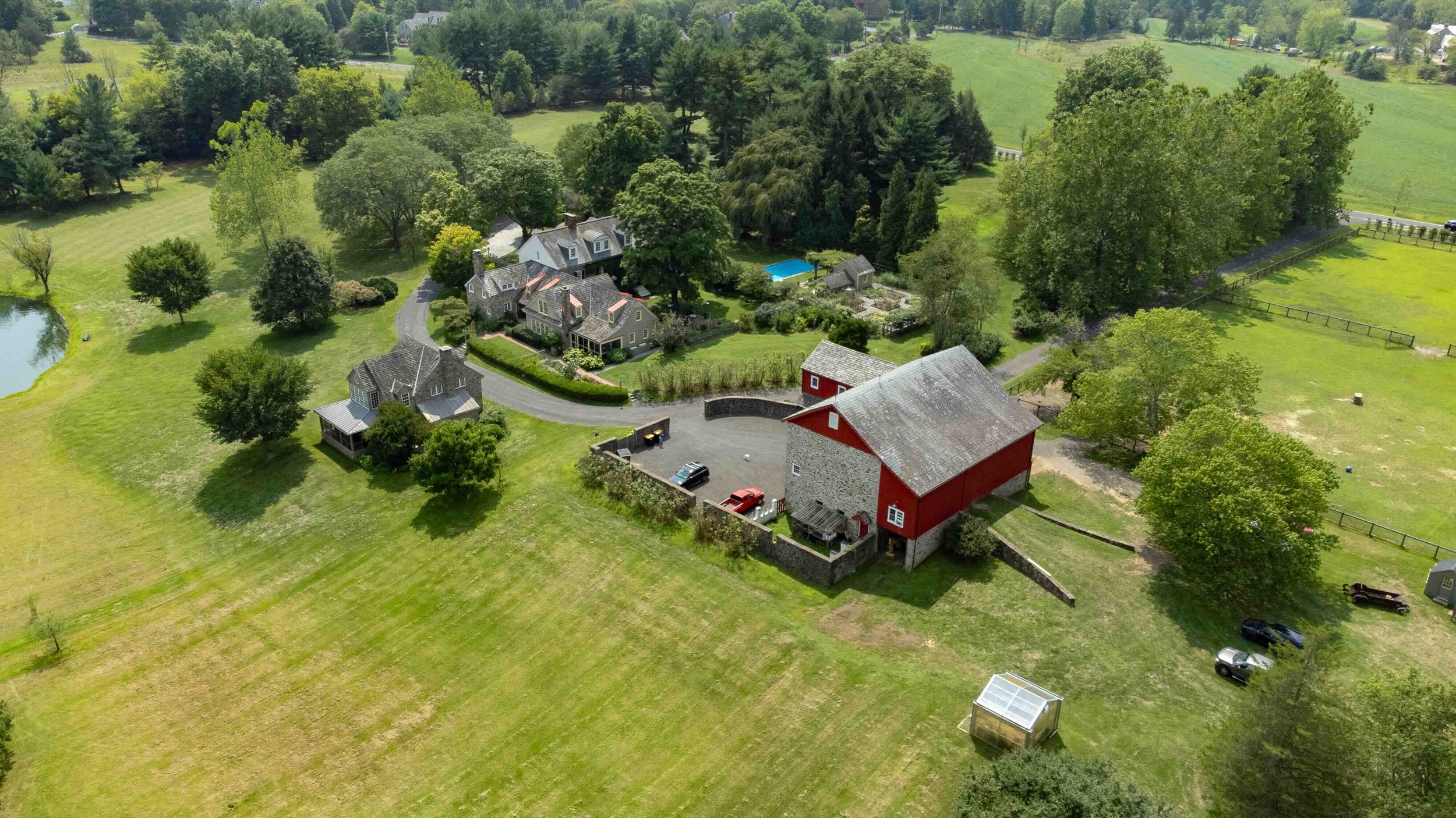
The Historic farmhouse and barn of London Purchase Farm

Property overview of London Purchase Farm
Challenges & Creative Solutions
Designing a map that met modern standards for usability while preserving the delicate charm of 1700s cartographyrequired a thoughtful and iterative approach. We overcame this challenge by:
Using layered cartography services to simplify wayfinding
Employing custom typography and color palettes to mimic vintage ink and parchment
Balancing dense tree labeling with negative space to enhance clarity
The result: a highly detailed yet legible map that fits seamlessly into the historic narrative of London Purchase Farm.
Website & Digital Integration
The final phase of the project was launching a dedicated website for the arboretum, which brings together:
An interactive map embedded with tree descriptions and aerial photos
Drone video content showcasing the grounds from above
A timeline and historical overview of London Purchase Farm
Downloadable map brochure for guests
This digital platform extends the educational and experiential value of the arboretum to online audiences.

Website design for London Purchase Farm Arboretum including custom graphics and fonts
Final Deliverables
Custom illustrated arboretum map (digital + print-ready)
Drone video and aerial imagery for web and print use
Printed brochure for on-site guest use
Fully responsive website with interactive content

London Purchase Farm Custom Map Design brochure