
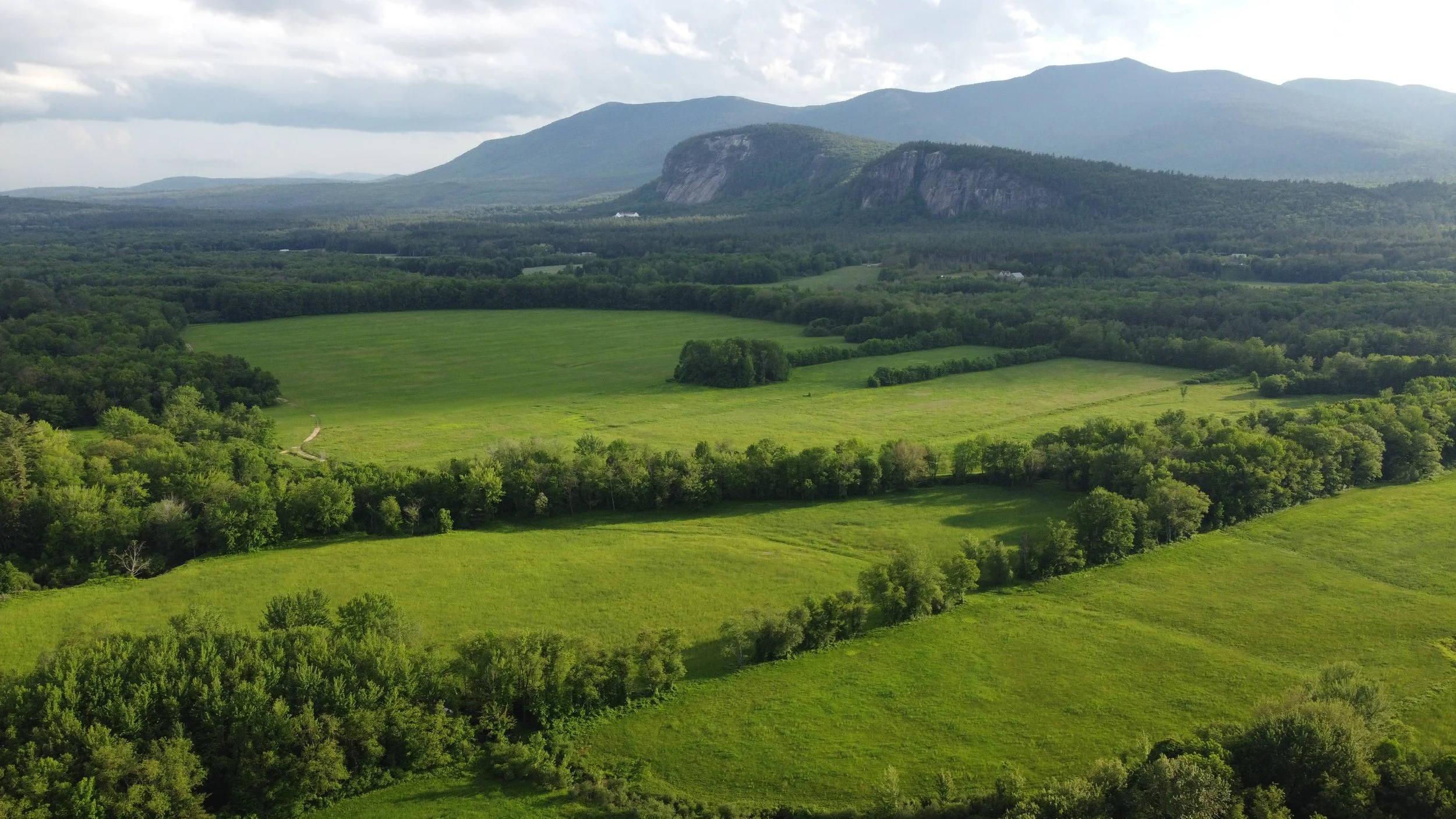
Drone Services Built with Nature in Mind
Drone imagery and mapping services tailored for conservation, landscape architecture, and outdoor recreation, in Philadelphia and surroundings.
We Fly Different.
At McNaught Design, we elevate drone imagery by blending technical precision with artistic excellence. With a foundation in landscape architecture and 3D modeling, we create visually stunning and design focused imagery to inform better decision making, enhance client communication, and reduce project costs.
Our mission is to provide customized, high-quality aerial imagery and mapping solutions that empower designers, planners, and businesses to see their projects from a new perspective.
McNaught Design LLC uses commercially insured drones operated by a FAA Part 107 Licensed Pilot.
Drone Services for Design Pros
McNaught Design offers professional level drone services for Philadelphia and beyond. All our services can be combined, just let us know what your project needs. We are here to help!.
Video Production
Aerial Imagery
Orthomosaic Mapping
3D Scanning
High Quality Aerial Imagery
We capture high-resolution georeferenced aerial imagery that highlights landscapes, architecture, and site features with clarity and artistry.
Perfect for portfolios, planning documents, marketing materials, and storytelling.
High Res Video
Our drone video services utilize stabilized gimbal mounted 4K cameras to capture smooth, low-altitude footage for project documentation, site analysis, and marketing. Flights are carefully planned to match project goals and spatial context
Orthomosaic Maps & Plans
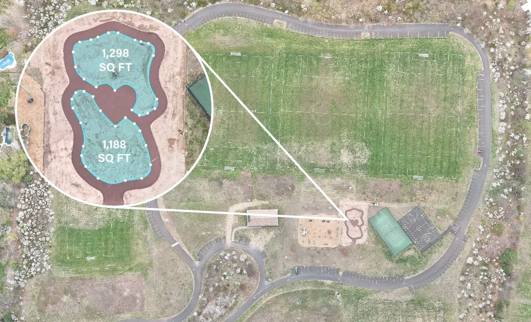
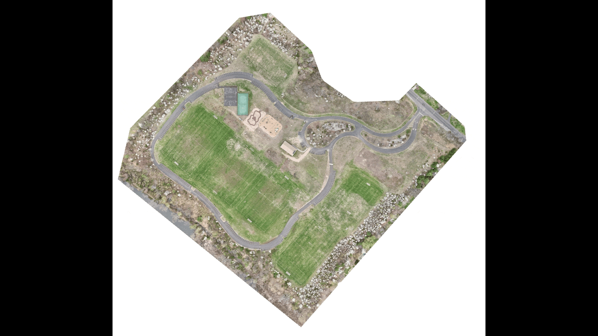
Using photogrammetry workflows, we produce high-accuracy orthomosaic maps from overlapping drone imagery. These georeferenced raster outputs are suitable for GIS integration, spatial analysis, base mapping, and design overlays.
Get real time aerial insights into your project with accurate measurements and area takeoffs, perfect for park construction projects.
Detailed 3D Scanning
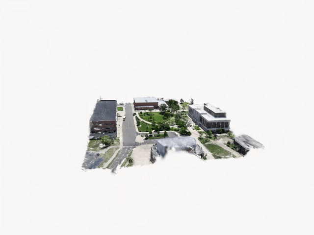
Our 3D scanning services employ structure-from-motion (SfM) photogrammetry to generate dense point clouds and textured meshes of terrain, structures, and vegetation. Output formats include OBJ, STL, and FBX, supporting CAD, BIM, and GIS workflows.
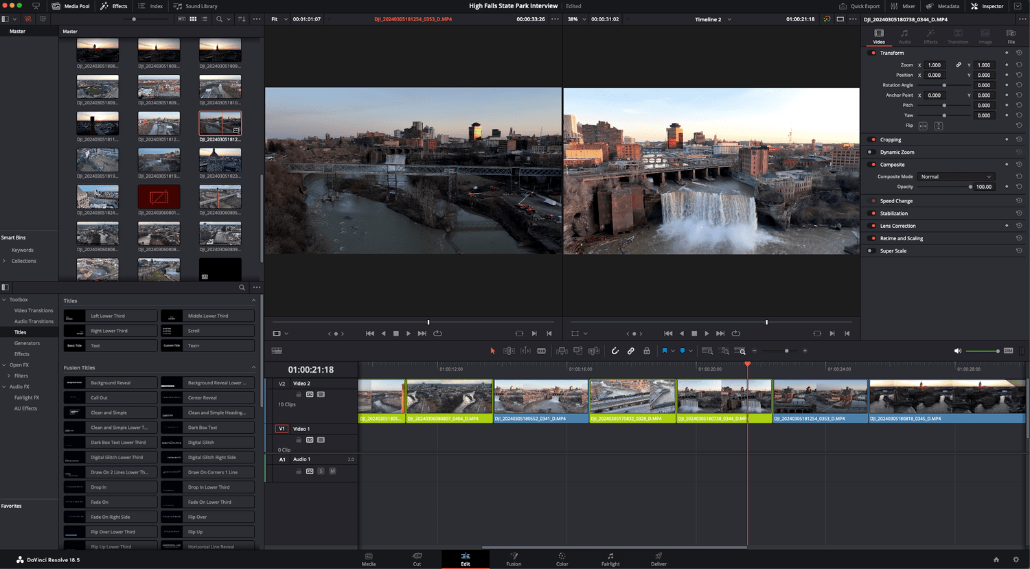
Editing & Video Production
Turn raw drone footage into beautiful productions that will impress clients and show off your finished designs. We will custom build a drone reel with music for your marketing needs.
So, how can McNaught Design support your project?

Why Choose McNaught Design
With a background in landscape architecture, founder Evan McNaught has collaborated with drone pilots across the country and encountered a common problem; marketing companies and photographers often lacked an understanding of the complex designs they were filming. This gap in technical expertise led to missed details, uninformed decisions, and higher project costs.
McNaught Design was created to bridge the gap between stunning visuals and meaningful data. We provide high quality drone footage, precise scans, and detailed imagery that not only look impressive but also deliver real value to designers, planners, and clients. Our experience ensures that every aerial shot is tailored to inform better decision making, enhance client feedback, and reduce costly revisions, all from the perspective of a fellow designer who understands your needs.
When choosing a drone imagery service, don’t leave it to chance. Work with a team that combines artistic vision with technical precision to bring your project to life.

McNaught Design in
Our Clients


Industries Served
Arboretums & Gardens
Design & Landscape Architecture


Parks & Trail Systems
Conservation & Agriculture


Coastal Research
Historic Preservation


Education & Campuses
Real Estate


Outdoor Adventure & Tourism
Urban Planning & Construction
68%
Increase in project attention
Why Drone Imagery Matters
Projects with aerial imagery are 68% more likely to attract attention and sell faster, and firms using drone footage report improved site analysis, faster data collection, and more compelling storytelling. With the drone services market projected to exceed $4.8 billion by 2035, high-quality aerial visuals are becoming essential for winning work and communicating design impact.
Recent Projects

Rittenhouse Hill Apartments
Rittenhouse Hill Apartments in Philadelphia were an outdated eyesore in northwest Philadelphia until Post Brothers purchased the property and transformed it into a new luxury apartment with outdoor amenities. McNaught Design provided footage of the new courtyard and trails during a stunning Philly sunset.

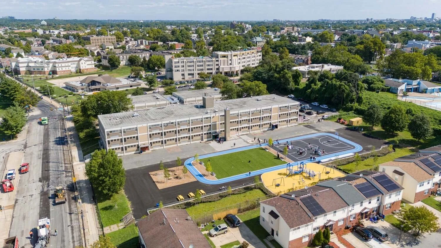
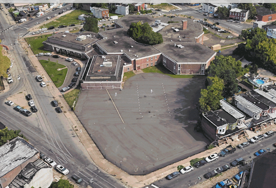
Mary McLeod Bethune School
The schoolyard at the Mary McLeod Bethune School in North Philadelphia was transformed from an asphalt parking lot into a playground dream. The project was completed by the Trust for Public Land and OLIN in 2024 and provided a significant outdoor amenity in the neighborhood. McNaught Design filmed the grand opening of the new playground.

London Purchase Farm
London Purchase Farm is a historic property in Bucks County that is on the National Register of Historic Places. During the American Revolutionary War, London Purchase Farm played a significant role as the headquarters for General Henry Knox and Captain Alexander Hamilton in December 1776. We recently flew drone footage for a website refresh and arboretum update that shows off the beauty of this historic farm.
Testimonials
-
My marketing team needed some select drone shots of a property in a pinch, and I'm so glad that Evan was referred to us. Not only did he produce beautiful work, but his delivery was incredibly fast. He was such a pleasure to work with—if you need drone photos and video footage...he's your guy.
Krista Arnold - Post Brothers
-
Evan produced extraordinary imagery for our Bethune and Locke Schoolyard projects. His skill and abilities revealed new and fresh perspectives that made the projects feel even more extraordinary. He is an absolute joy to work with!
Demetrios Staurinos - OLIN
-
Evan at McNaught Design is one of the most professional and knowledgeable creatives I've ever worked with. His passion for the natural world, comes through in every piece he creates. The creative vision he has is only amplified by his skills and abilities as a licensed drone pilot. and When working with Evan I knew I was hiring an experienced professional; one stop shop on every front! I would recommend McNaught Design to anyone looking for a beautiful custom map or ancillary drone services, you wont regret it!
James Bonanno - JB Films
Frequently Asked Questions
-
We offer several professional grade drone services for projects in Philadelphia and the Northeast including aerial photography, drone video , 3D scanning and mapping, and drone video editing. All our services can be combined and tailored to meet your specific project needs.
-
McNaught Design is based out of Philadelphia, Pennsylvania and serves the Northeast United States. Depending on the job we will travel to the following states: Pennsylvania, New Jersey, Delaware, Maryland, New York, New Hampshire, Vermont, and Maine.
-
Yes! McNaught Design only uses drones that are commercially insured and operated by a FAA Part 107 Licensed Pilot. We follow all FAA guidelines and will get permission to fly in any airspace where it is needed.
-
Absolutely. These are some of our favorite sectors to work in and McNaught Design’s roots in landscape architecture make us particularly equipped to collaborate with designers and conservancies. We know that good site analysis can save thousands of hours over the course of project, meaning more money and time to design. We are dedicated to giving you the best information possible.
-
Yes! McNaught Design is dedicated to long term projects. That means we will capture photo, videos, or 3d scans on a repeating schedule that fits your project needs. Tracking vegetation health, constructing a new park or building, or want to see a site through the seasons? We have you covered.
-
We fly the DJI Air 3 for photo and video jobs in combination with the DJI Mini 2 for remote work and drone mapping. Together the two drones provide a combination of versatility, 4K cameras, and mapping capabilities.
Blog

Contact Us
Here for Philadelphia and surroundings with drone imagery, 4k video, and 3D scans.
Let us know how we can help!